|
|
Maps
Oct 6, 2013 6:44:56 GMT
Post by questa on Oct 6, 2013 6:44:56 GMT
|
|
|
|
Maps
Oct 6, 2013 15:05:24 GMT
Post by Deleted on Oct 6, 2013 15:05:24 GMT
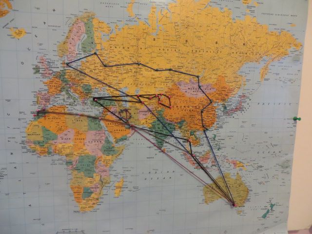
Those are great. I have a world map somewhere where I marked all of the flights I took over the years. It needs a little bit up updating, but I'll try to take a picture of it when I do.
|
|
|
|
Maps
Oct 6, 2013 18:26:32 GMT
Post by bixaorellana on Oct 6, 2013 18:26:32 GMT
Brilliant! What do the different colors of yarn indicate?
Also, is it okay to ask what the prize ribbons are for?
|
|
|
|
Maps
Oct 6, 2013 22:34:51 GMT
Post by questa on Oct 6, 2013 22:34:51 GMT
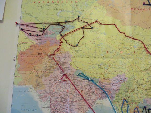
Bix, you have eyes like an eagle!
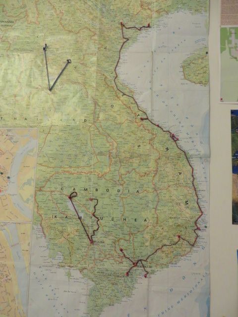
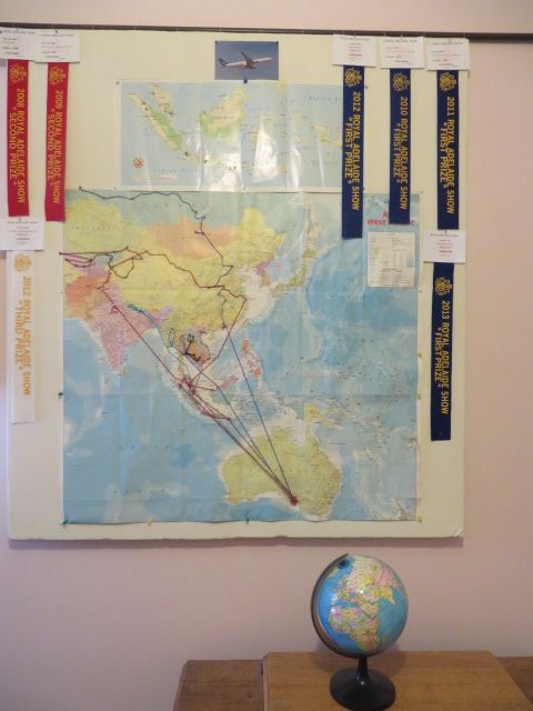
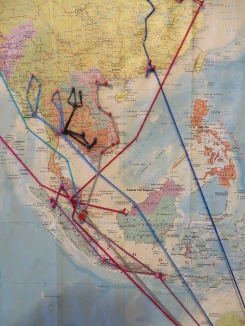
Each colour yarn is a trip I have done. I no longer count the Oz to S'pore /Bangkok / Kuala Lumpur or Dubai sector as the pin board was getting clogged up.
The ribbons? Each year there is a Royal Show in September where there are nation wide competitions for everything from agriculture, horticulture, cooking and crafts.
I am an Extreme Knitter (my sons' terminology) in that I research something "different" each year and knit it for the Show. I sometimes do my own designs, or do a historical museum piece. I have been invited to join the Guild of Handknitters, but so far haven't got round to it.
Do we have a thread where I can share some of my winning entries with you?
|
|
|
|
Maps
Oct 6, 2013 22:52:57 GMT
Post by bixaorellana on Oct 6, 2013 22:52:57 GMT
Oh my goodness, Questa ~~ you'll have an avid audience for your creations. Why don't you create a thread in Maritime Museum?
|
|
|
|
Maps
Oct 7, 2013 3:38:25 GMT
Post by htmb on Oct 7, 2013 3:38:25 GMT
Seen at a Georgetown bookstore 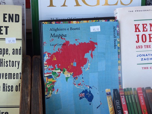 Quoted from Amazon |
|
|
|
Maps
Oct 7, 2013 4:40:00 GMT
Post by Deleted on Oct 7, 2013 4:40:00 GMT
Some day I will finally make it to the International Festival of Geography which was held this last weekend in Saint Dié-des-Vosges. It's not a very huge city, but year after year, people keep saying that this is a really fine event. It also happens to be the town where my great-grandparents are buried. Saint Dié has the peculiar honour of being "the town where America was named" because the very first map using that name was printed there in 1507, in a book called Cosmographiae Introductio. |
|
|
|
Maps
Dec 28, 2013 16:39:02 GMT
Post by Deleted on Dec 28, 2013 16:39:02 GMT
I have not visited this thread in awhile. How very cool Questa!!!! While in NYC I did my usual ritual of acquiring Metro maps. There was a time when they were scarce because people actually utilized them. Now with all the high tech smart phones etc. people have become reliant on their electronic gadgets for transport. I got a map of Brooklyn, Staten Island, Bronx, Manhattan (subway and bus!!) and one of Queens. Maybe I should have posted this in the hoarding thread  .... |
|
|
|
Maps
Dec 28, 2013 17:26:41 GMT
Post by bjd on Dec 28, 2013 17:26:41 GMT
A friend of my daughter's is a professional geographer/city planner and collects maps of city transport systems. My daughter always picked some up for him when she went somewhere new.
And we have loads of maps of cities too, although my husband finally started to throw things out recently and binned a few maps of places he will never return to.
|
|
|
|
Maps
Dec 28, 2013 18:58:46 GMT
Post by Deleted on Dec 28, 2013 18:58:46 GMT
That's cool BJD. I heard an interview with a gentleman on NPR sometime in the last 6 months who does the same. It was fascinating. I wonder if the same chap your daughter knows. I will try to search for it. One of the coolest Christmas gifts I received, is a book I've always lusted after and my neighbour gave me one. It's called Charting Louisiana and is gorgeous. It's also huge, and I mean huge!!! www.hnoc.org/publications/books-atlas.html |
|
|
|
Maps
Dec 28, 2013 20:39:39 GMT
Post by bjd on Dec 28, 2013 20:39:39 GMT
Surely not the same guy -- hers is a French university friend.
|
|
|
|
Maps
Jan 3, 2014 14:47:55 GMT
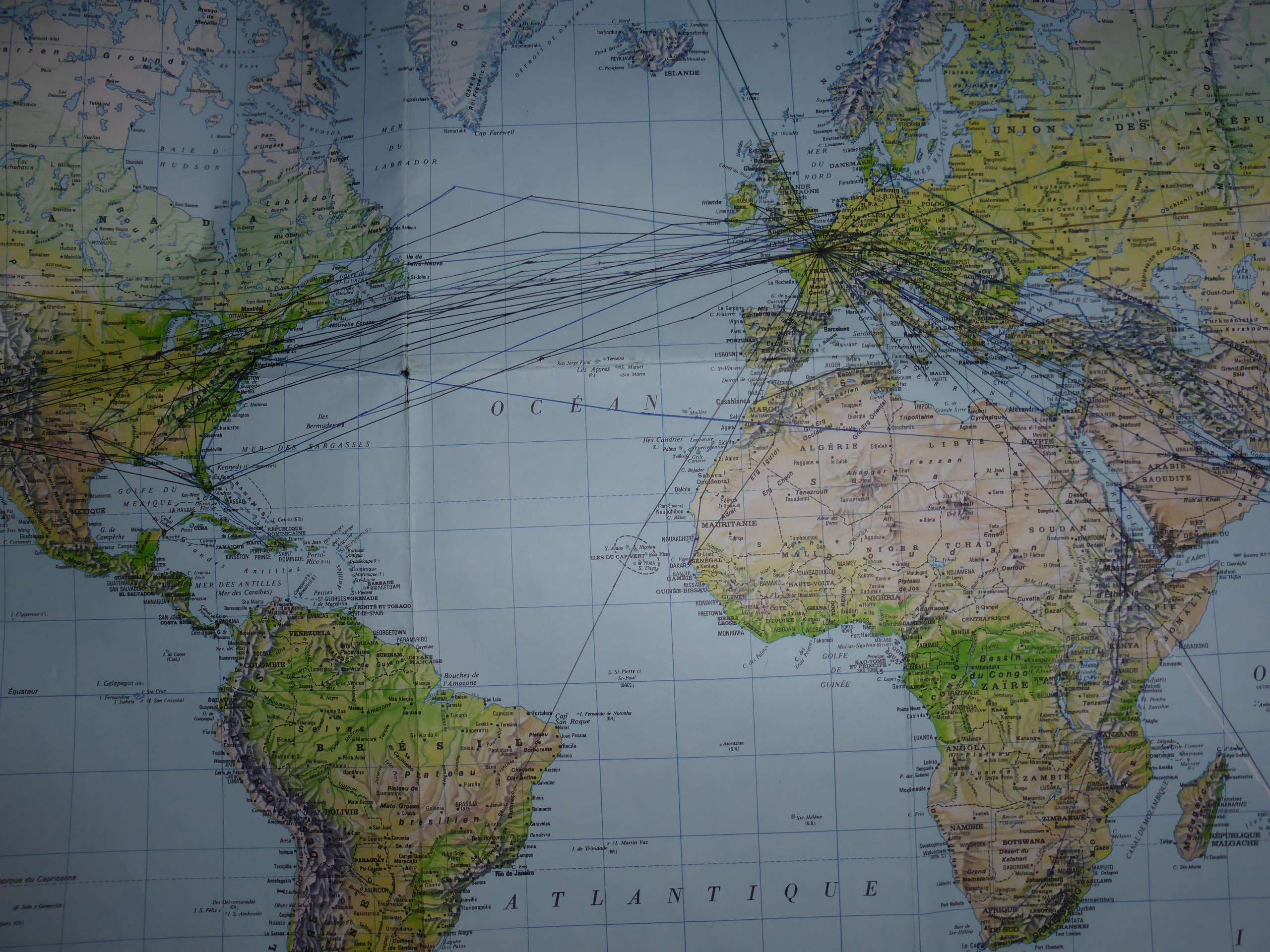
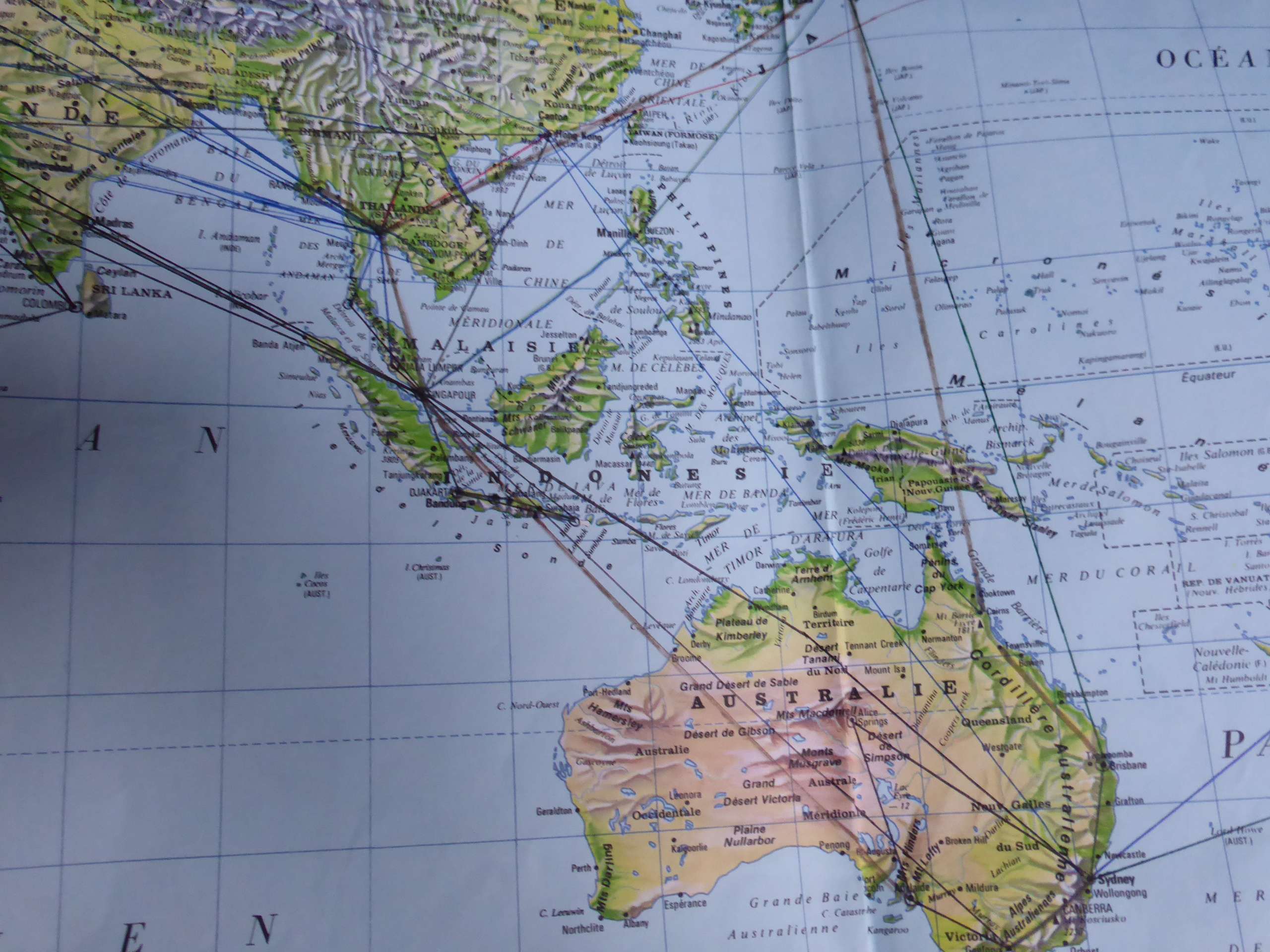
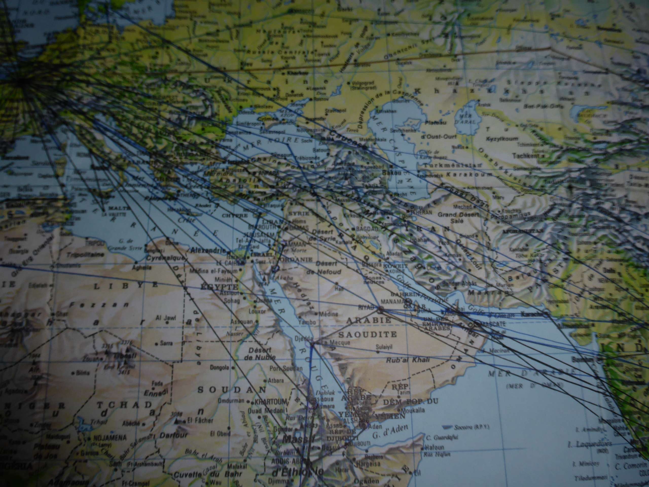
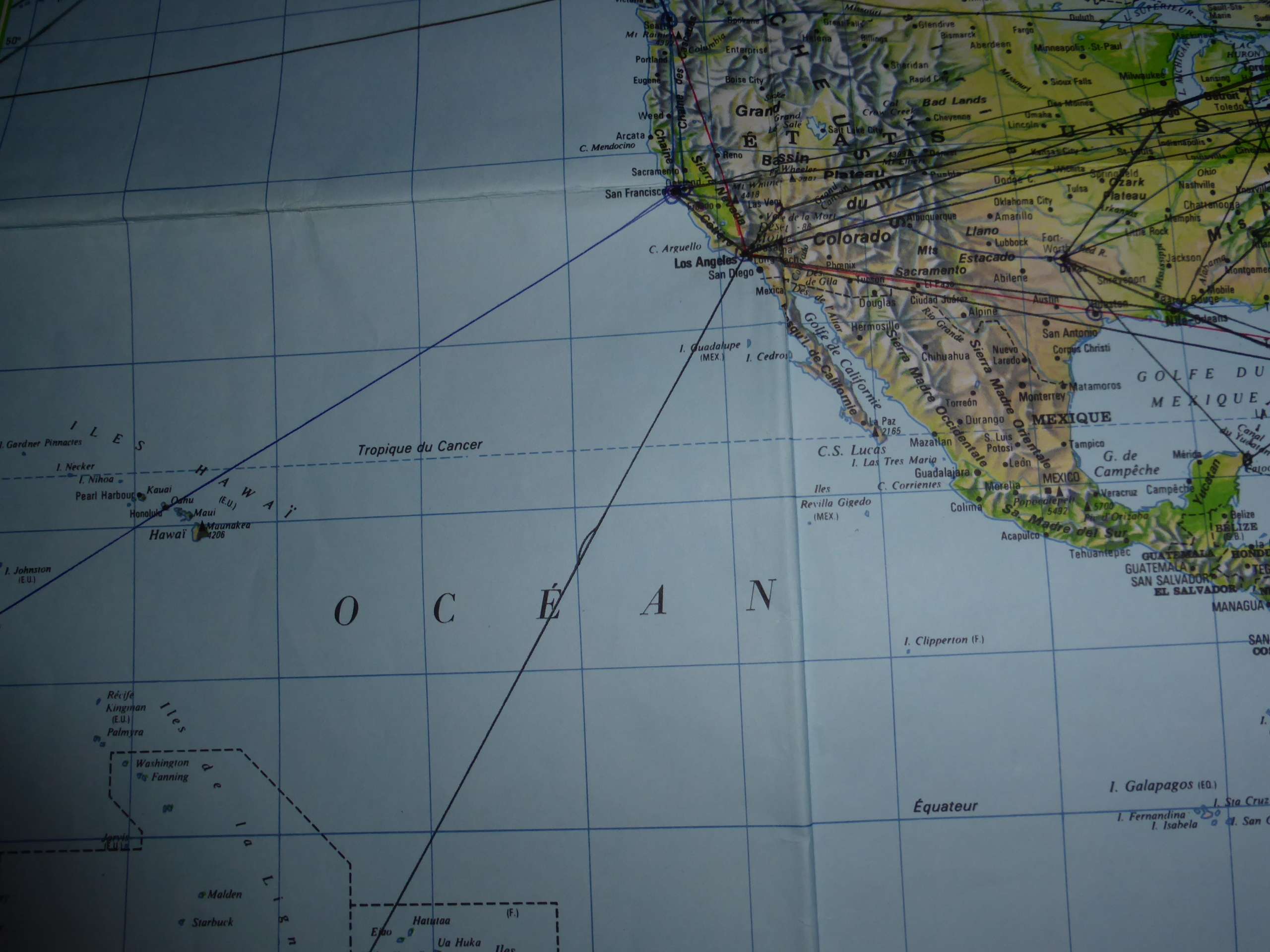
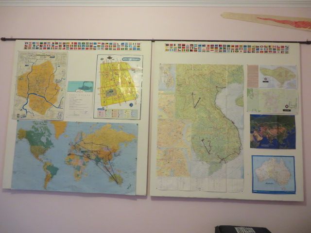
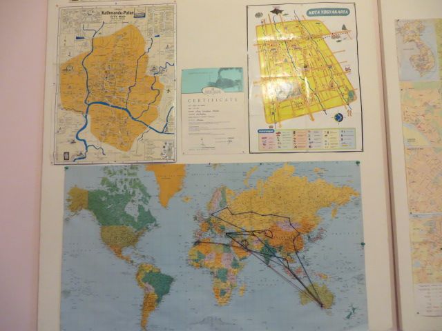
Post by Deleted on Jan 3, 2014 14:47:55 GMT
|
|
|
|
Maps
Jan 3, 2014 14:57:29 GMT
Post by Deleted on Jan 3, 2014 14:57:29 GMT
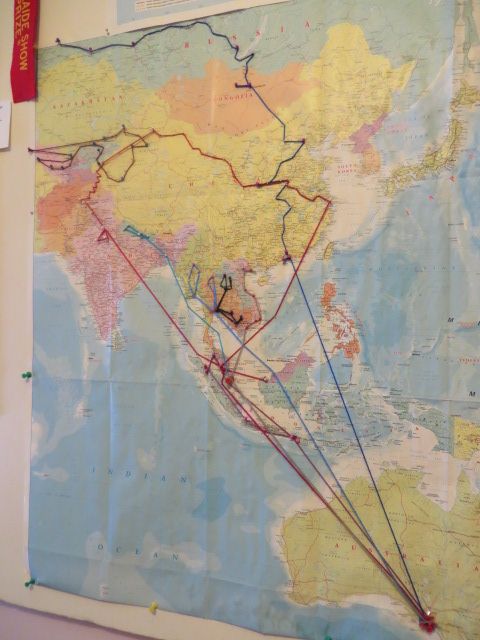
Wow!!!! So very cool Kerouac!! I am impressed and envious.
Thanks for sharing this with us. I knew that you had traveled a lot but, seeing it in this context is awesome.
|
|
|
|
Maps
Jan 4, 2014 4:50:30 GMT
Post by htmb on Jan 4, 2014 4:50:30 GMT
Very impressive is putting it mildly. Wow!
|
|
|
|
Maps
Jan 4, 2014 5:28:03 GMT
Post by Deleted on Jan 4, 2014 5:28:03 GMT
There is a certain utility to marking a map to peruse in later years, because I have no memory at all of flying directly to Sydney from Alice Springs. I thought I went through Adelaide both coming and going.
|
|
|
|
Maps
Jan 4, 2014 16:04:48 GMT
Post by htmb on Jan 4, 2014 16:04:48 GMT
On a much humbler scale, I would really like to get a nice, large paper map of Paris so I can mark off the routes I walk in the future. I think it would be a great visual for me to not only see when I have been, but to also help in planning visits to other parts of the city. My favorite thing to do in Paris is to wander and explore for hours at a time.
|
|
|
|
Maps
Jan 4, 2014 16:11:25 GMT
Post by Deleted on Jan 4, 2014 16:11:25 GMT
I used highlighters on a Michelin map of France for a long time to see all of the roads on which I had driven, but after awhile it just looked like a mess so I stopped.
Regarding using maps of Paris, there was a time when I would walk about Paris with a notebook and draw my own map as I went along with all of the crooked angles and curves and the odd intersections. Later at home, I would compare what I had done to a real map to see how far off I was in terms of the compass points. Usually my handmade route had very little relation to reality because that streets are often going off at an angle even when you don't realize it.
|
|
|
|
Maps
Jan 4, 2014 16:16:18 GMT
Post by htmb on Jan 4, 2014 16:16:18 GMT
In the past I've taken photos of intersection signs and compared them to maps later. It also helps for when I get lost. I can just refer back to the photos on my camera, kind of like dropping breadcrumbs along the way.  |
|
|
|
Maps
Jan 4, 2014 16:25:13 GMT
Post by Deleted on Jan 4, 2014 16:25:13 GMT
I have to say the same as everyone else. Wow. That is some major flying you have done, Kerouac. I wonder if there is any air-line or flight that stands out to you, just off-hand, for any reason?
|
|
|
|
Maps
Jan 4, 2014 17:18:17 GMT
Post by bjd on Jan 4, 2014 17:18:17 GMT
htmb, Michelin makes a good large paper map of Paris. You can easily find one in a store like Gibert or a large supermarket with a book section.
|
|
|
|
Maps
Jan 4, 2014 17:41:44 GMT
Post by htmb on Jan 4, 2014 17:41:44 GMT
Perfect! Thanks for the information, bjd.
|
|
|
|
Maps
Jan 4, 2014 19:22:48 GMT
Post by bjd on Jan 4, 2014 19:22:48 GMT
|
|
|
|
Maps
Jan 4, 2014 19:41:03 GMT
Post by Deleted on Jan 4, 2014 19:41:03 GMT
Every map imaginable can be bought at FNAC in Paris or at the IGN shop on rue de la Verrerie just behind the BHV/Marais.
|
|
|
|
Maps
Jan 4, 2014 19:50:09 GMT
Post by htmb on Jan 4, 2014 19:50:09 GMT
Thanks for the link, bjd. There seems to be a similar map on the US version of Amazon. How big is the map you have now?
|
|
|
|
Maps
Jan 4, 2014 20:14:15 GMT
Post by mossie on Jan 4, 2014 20:14:15 GMT
I guess the Michelin is the way to go.
I was going to suggest the cheapskate method. next time you are in a Metro station ask the clerk for "un grand plan avec rues".
|
|
|
|
Maps
Jan 4, 2014 20:18:51 GMT
Post by htmb on Jan 4, 2014 20:18:51 GMT
I have a really good French booklet type of a map of Paris, and a little single page, fold-up map. Both are plastic coated and have served me well for a few years. What I'm looking for now is a large size map that I can tape to the wall and mark my paths around the city. I'm a very visual person, and this type of thing could be helpful, plus I can see where I went after the fact.
And pat myself on the back for all the walking.
|
|
|
|
Maps
Jan 5, 2014 0:03:52 GMT
Post by Deleted on Jan 5, 2014 0:03:52 GMT
It will also help you to determine what you have not seen yet, obviously. My recent discovery of the entire "petite ceinture" around Paris was a real eye opener about parts of the city that I had never seen, even after all of these years.
|
|
|
|
Maps
Jan 5, 2014 0:12:34 GMT
Post by htmb on Jan 5, 2014 0:12:34 GMT
True, Kerouac. It may also serve to challenge me on days I'm prone to laze around. Bjd, maybe I can talk you into delivering a map in person. |
|
|
|
Maps
Jan 5, 2014 9:38:39 GMT
Post by Deleted on Jan 5, 2014 9:38:39 GMT
And then there are route maps! The other day I rode the full length of the new T7 tramway line in the suburbs which goes through (and under) Orly airport and which also serves no fewer than three suburban shopping malls, and also the national wholesale food market of Rungis, which is always useful to know. And it also passes in front of the giant cemetery of Thiais where that friend of mine was buried. 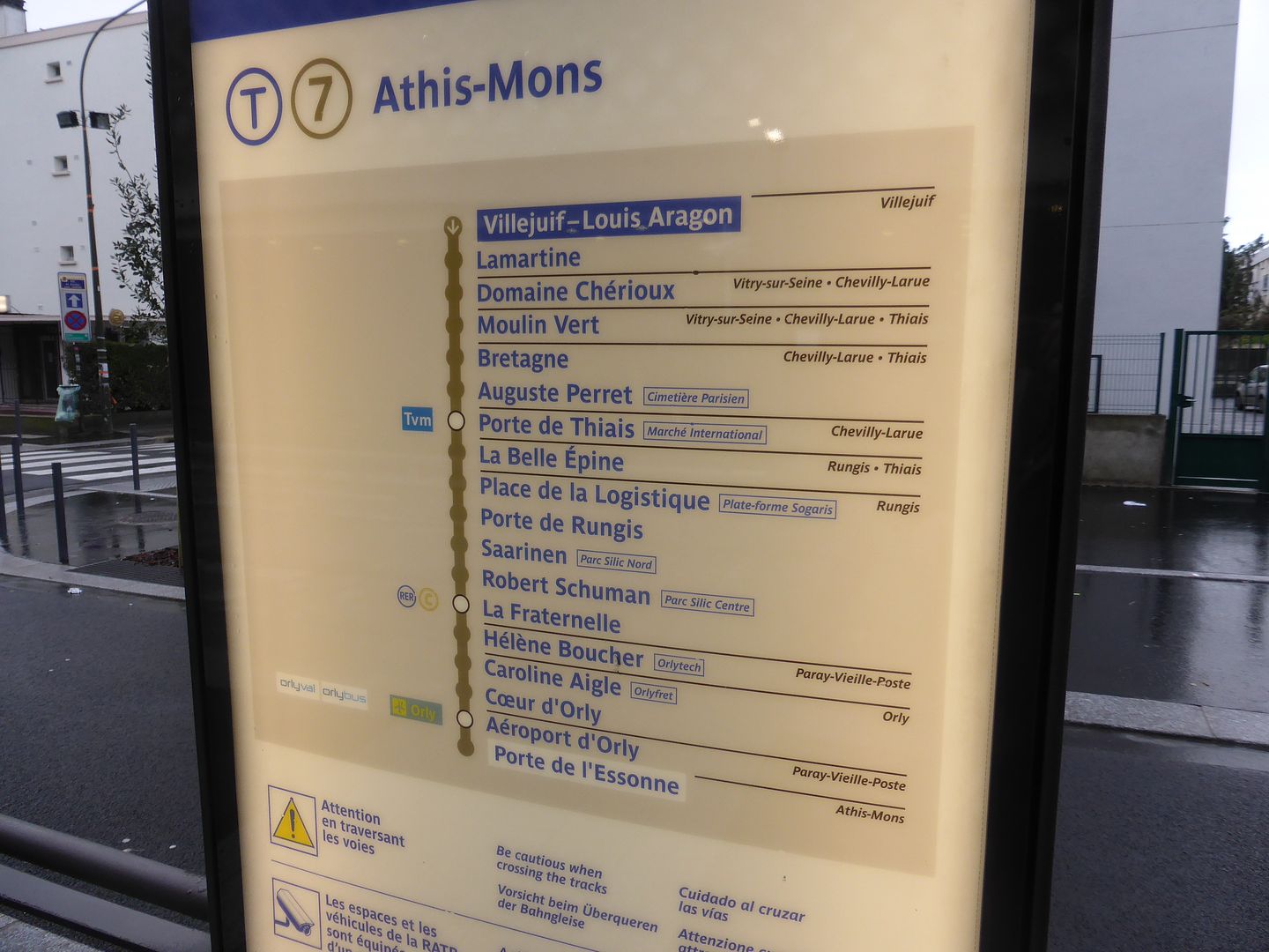 |
|
|
|
Maps
Jan 11, 2014 14:25:19 GMT
Post by lola on Jan 11, 2014 14:25:19 GMT
Forgive me if this is badly misfiled. I've gotten even worse at the search function lately. Looking for London Bike Path maps led me to the Thames bike path, which brought up the question of current flooding as far downstream as Old Windsor, and this interactive map, which can tell you river stages at different points on a given river. Things are fine at Greenwich, not so peachy elsewhere: www.environment-agency.gov.uk/homeandleisure/floods/riverlevels/default.aspx |
|


 ....
....