|
|
Maps
Jan 10, 2019 18:36:46 GMT
Post by bixaorellana on Jan 10, 2019 18:36:46 GMT
That's a fascinating story, Questa! I read a book about the stringing of the telegraph line from Port Augusta near Adelaide to Darwin. As with many stories about the settling of Australia, it seems completely impossible. |
|
|
|
Maps
Jan 11, 2019 2:09:35 GMT
Post by questa on Jan 11, 2019 2:09:35 GMT
Bixa, if you liked Todd's story you will love the books by Len Beadell. When the European Launch and Development Organisation wanted a site to test rockets etc, they gave the job of finding a base and retrieval sites in the desert to an army surveyor, Len. (This was in post Bomb early 1950's ) He chose a site 200km north of Port Augusta as it had a water hole nearby. With his crew of bulldozer and grader drivers, cook van and tents, aboriginal interpreters and fuel tankers he laid out the township of Woomera. The builders came in next and the town took shape (my m-i-law won a contract for 200 homes to be built)
Then came the roads...look at an Oz map...Alice Springs...in the middle. See all those roads that fan out through the deserts, NW, West, SW...he built them and named them. The Great Sandy Desert, Great Central dst, Gibson dst, Great Victoria dst, Tanami dst and the Simpson Dst.
His most famous road is the "Gunbarrel Highway" It is "an isolated desert track in the Northern Territory, South Australia and Western Australia." It consists of about 1,350 km (840 mi) of washaways, heavy corrugations, stone, sand and flood plains." ..." The name comes from Len Beadell's Gunbarrel Road Construction Party so named as his intention was to build roads as straight as a gunbarrel.".(Wiki)
His books are funny (mostly) but it is the way he and the land interact that makes for great reading. He used to come to our car club meetings and show us how to get out of trouble when stuck. He is accepted as the last genuine explorer in Oz history. Here are his books.
Books by Len Beadell
Beadell, Len (1976). Beating About the Bush. New Holland Publishers(Australia). ISBN 1-876622-15-6.
Beadell, Len (1967). Blast The Bush. Lansdowne Publishing. ISBN 1-86302-618-5.
Beadell, Len (1971). Bush Bashers. New Holland Publishers (Australia). ISBN 1-86436-734-2.
Beadell, Len (1983). End of an Era. New Holland Publishers (Australia). ISBN 1-86436-733-4.
Beadell, Len (1975). Still in the Bush. Rigby Limited,Adelaide. ISBN 0-7270-0020-9.
Beadell, Len (1965). Too Long in the Bush. New Holland Publishers (Australia). ISBN 1-86436-719-9.
Beadell, Len (1979). Outback highways (compilation of the above). Adelaide South Australia: Rigby. ISBN 0727010832.
Beadell, Len (1997). Around the World in 80 Delays. Corkwood Press, North Adelaide SA. ISBN 1-87624-702-9.
|
|
|
|
Maps
Jan 11, 2019 6:06:48 GMT
Post by bixaorellana on Jan 11, 2019 6:06:48 GMT
Incredible that all that happened in modern times!
|
|
|
|
Maps
Feb 15, 2020 4:14:35 GMT
Post by bixaorellana on Feb 15, 2020 4:14:35 GMT
|
|
|
|
Maps
Feb 15, 2020 9:02:10 GMT
Post by questa on Feb 15, 2020 9:02:10 GMT
Us mappies have to stick together and not get confused with the charties. They are the people who use maps of water-borne vessels orr fly through the air.
Well, actually maps that show seas or rivers, or those in aircraft, are called charts.
|
|
|
|
Maps
Mar 1, 2020 15:33:22 GMT
Post by bixaorellana on Mar 1, 2020 15:33:22 GMT
|
|
|
|
Maps
Mar 1, 2020 18:55:30 GMT
Post by kerouac2 on Mar 1, 2020 18:55:30 GMT
That is quite amusing.
|
|
|
|
Maps
Mar 2, 2020 8:16:35 GMT
Post by mossie on Mar 2, 2020 8:16:35 GMT
Being pedantic about Questa's post 124. When I was navigating an aircraft I carried two large sheets of paper. One was the 'chart' showing coastlines, latitude and longitude, and a scale, on which one plotted out ones proposed course, as the flight progressed ones position was plotted with time, from which one calculated the direction and strength of the wind, and course was altered and ETA corrected, if necessary, to reach the next turning point or destination. The other was a "topo', or topographical map, which showed coasts, rivers, roads, towns etc., etc., to enable one to stick ones head out of the window and match features on the ground with the map and so determine ones position. To do this one carried a long ruler, a square protractor which could also be used for other stuff, a pair of dividers for measuring distance, a pencil with a spare and a sickbag. But most important was the Computor, a little box with a roll of fabric inside which could be wound up to show the relevant speed one was flying through a window on top of the box, round the window was a ring ro turn, marked off in degrees. On the back of the box was a circular slide rule.
Navigating something like a Mosquito was a juggling act, one was confined beside a busy pilot in a cockpit like a sports car and balancing all this kit on ones knees with the chart mounted on a clipboard. To plot ones course required accurate drawing on the chart as generally 1/16th of an inch on the chart was a mile on the ground, and it was necessary to be at least that accurate. So don't use a blunt pencil.
|
|
|
|
Maps
Mar 3, 2020 10:06:52 GMT
Post by questa on Mar 3, 2020 10:06:52 GMT
Mossie, you bring back memories of rally driving in my youth. Unlike today's guys who practise on the set tracks and the navigator calls the road for them, our rallies were navigation based. We used the army ordnance maps, usually 1 = 630,000 or 1 = 5000 after metric. We would have a series of tasks to get from control to control,eg Arrive at map reference 123 456 after passing through intersections 789101 and 234 567, each from a northerly direction. Mileage 30m time allowed 55 mins.
The driver would have to keep in speed limits and the navigator would be trying to find the intersections then find the "shortest mapped route"to the control.It was fun working with maps. They are always read with the horizontal numbers then the vertical. "you gotta get across before you get up" was the rule.
|
|
|
|
Maps
Mar 3, 2020 17:00:15 GMT
Post by kerouac2 on Mar 3, 2020 17:00:15 GMT
On UTA flights many years ago -- before individual screens showed the flight route -- the navigator would post a paper map on the wall next to the galley every hour to show the progression of the flight and any deviations due to weather. I liked that system.
|
|
|
|
Maps
Mar 13, 2020 13:15:58 GMT
Post by lagatta on Mar 13, 2020 13:15:58 GMT
Thinking of Questa's comment about someone confusing the locations of Sydney and Perth, when I was studying in Italy, a teacher asked me if I knew another student - who was from Vancouver.
|
|
|
|
Maps
Mar 13, 2020 15:37:42 GMT
Post by kerouac2 on Mar 13, 2020 15:37:42 GMT
If you visit your country cousins in French villages, they often think that Florida and California are right next to each other.
|
|
|
|
Maps
Oct 14, 2020 15:48:37 GMT
Post by bixaorellana on Oct 14, 2020 15:48:37 GMT
In order to access the big (really, really big!) version of this map, copy & paste https://i.redd.it/bbenafmaagp21.jpg into your browser. The picture will open up small, as shown below, but clicking on it will greatly expand it. Hint: the large version is so large that, once you have opened the link, it is easier to manipulate by expanding the small version to your liking, rather than going to the full sized version. You'll see what I mean once you open the link. Bird migration in the Americas, a National Geographic map:  |
|
|
|
Maps
Oct 17, 2020 4:19:57 GMT
Post by bixaorellana on Oct 17, 2020 4:19:57 GMT
More and varied maps in one place than you ever dreamed of! Some of these are fun, some make their points quickly, some need studying, all are fascinating: www.boredpanda.com/interesting-maps-data/Here is one of the fun ones, "What Pedestrians Look Like Across Europe": 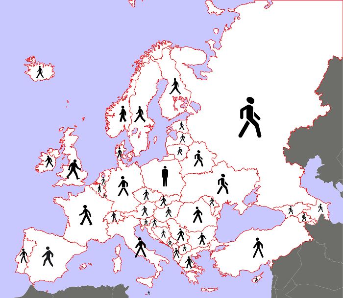 |
|
|
|
Maps
Oct 17, 2020 7:23:26 GMT
Post by mossie on Oct 17, 2020 7:23:26 GMT
Very interesting set of comparisons in one of the links.
In your example walkers feet have been cut off in many countries, must make walking difficult
|
|
|
|
Maps
Oct 17, 2020 10:10:50 GMT
Post by onlyMark on Oct 17, 2020 10:10:50 GMT
Mossie, I took this whilst being buffeted by the traffic in Cairo. It's the little green man at a pedestrian crossing.
In Egypt, you seem to be advised to not walk, but run across -
|
|
|
|
Maps
Oct 17, 2020 10:25:21 GMT
Post by mossie on Oct 17, 2020 10:25:21 GMT
Most definitely, run for your life. Better still, stay well clear of Cairo. There only seems to be one set of traffic lights and nobody takes any notice of them, they rely totally on sounding their horns to clear a path. Pedestrians are fair game.
|
|
|
|
Maps
Oct 17, 2020 13:51:06 GMT
Post by kerouac2 on Oct 17, 2020 13:51:06 GMT
That's how Cairo was the very first time I went there (around 1980), as well as being the dirtiest city I had ever seen. But when I went back the next time, two or three years later, it had been cleaned up quite a bit. Crossing the street is still a life-threatening event for pedestrians.
|
|
|
|
Maps
Nov 19, 2020 3:46:39 GMT
Post by bixaorellana on Nov 19, 2020 3:46:39 GMT
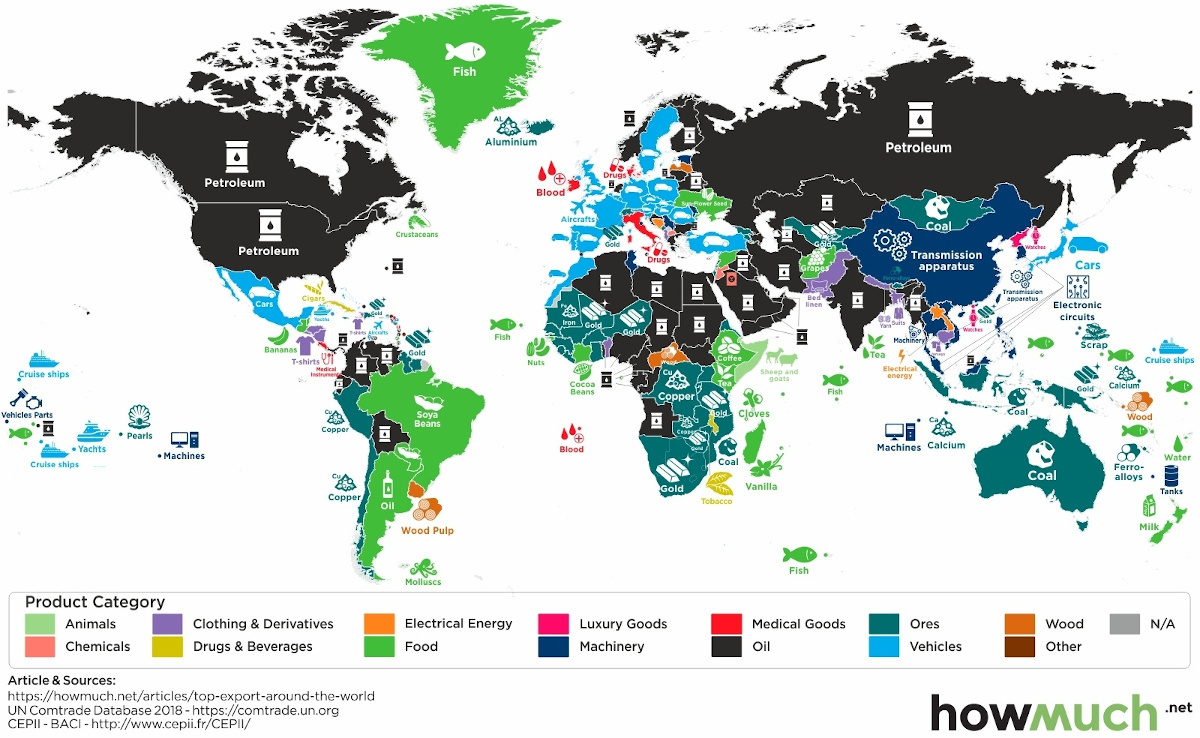
Top exports across the world. Click the link to access the site, with links to more information and detailed maps. |
|
|
|
Maps
Nov 19, 2020 7:29:56 GMT
Post by kerouac2 on Nov 19, 2020 7:29:56 GMT
Some of the results are surprising.
|
|
|
|
Maps
Nov 19, 2020 16:05:15 GMT
Post by fumobici on Nov 19, 2020 16:05:15 GMT
Happy to see North Korea as a major exporter of "Luxury Goods".
|
|
|
|
Maps
Nov 27, 2020 15:08:45 GMT
Post by casimira on Nov 27, 2020 15:08:45 GMT
I remember getting that NG map of North American Bird Migration and was so enthralled with it. Most especially because it shows how many birds pass through here in this region and many of them end up in the NE where I am from.
A friend of mine wanted to borrow it but, I would not let him because I feared I would never see it again.
Another really cool one is one that NG did of the Solar System.
I still fancy the idea of wallpapering a room with all the NG ones I have (100's). (I probably should have it done by somebody professionally) The older ones are printed on just one side so they would be ideal as the ink from the print on the back of them wouldn't "bleed" through. I learned this the hard way when I went to transform an old suitcase covered in maps and caught it right away as I saw the print from the back come through.
My favorite map remains one old (1930's) geographical survey map of the area where I grew up which I had the good sense of getting professionally framed with special museum quality glass that prevents and protects it from light damage. (it costs a bit more but is worth every penny.)
(A lesson I learned from having a beautiful print of a Walter Anderson watercolor of some pitcher plants framed which after years of light exposure has since faded and lost all it's colorful vibrancy.
Some thrift stores have old NG's and many of them still have the maps included and cost a mere 25 cents.
T. has the patience to go through them when he frequents his favorite thrift stores.
|
|
|
|
Maps
Nov 27, 2020 18:42:06 GMT
Post by fumobici on Nov 27, 2020 18:42:06 GMT
I loved those NG maps that came once or twice a year with the periodical. I remember the bird map, it was excellent. I used them as wall art but, unfortunately perhaps, none survived.
|
|
|
|
Maps
Nov 27, 2020 18:51:08 GMT
Post by kerouac2 on Nov 27, 2020 18:51:08 GMT
I have more than 10 years of National Geographic (and almost as many Geo) at home, and the time has come to dispose of them. Please make an appointment and I will try to be home to bestow them upon you. All of the maps are there.
|
|
|
|
Maps
Nov 27, 2020 19:00:33 GMT
Post by casimira on Nov 27, 2020 19:00:33 GMT
Yeah right Kerouac!! You'd be one off those people who would say, "no, not that one, I haven't finished that last article, and then, oh, not that one either, I wanna save that map...Oh!! I forgot all about that one..." I've met and know people like you...  |
|
|
|
Maps
Nov 27, 2020 19:13:09 GMT
Post by bjd on Nov 27, 2020 19:13:09 GMT
I have more than 10 years of National Geographic (and almost as many Geo) at home, and the time has come to dispose of them. Please make an appointment and I will try to be home to bestow them upon you. All of the maps are there. Before we moved from Toulouse, my husband tried to sell a bunch of stuff, most of which I would have taken to the dump or a charity place. One lady came to buy something and saw that we had 10 years worth of National Geographic magazines in English. She paid 10€ for the lot, thinking her kids might like them to learn English from.
|
|
|
|
Maps
Nov 27, 2020 19:14:03 GMT
Post by kerouac2 on Nov 27, 2020 19:14:03 GMT
People like me are the ones who subscribed to those publications and almost never read them, just flipping through the pages. I don't know why it takes ten years to realise that you never should have subscribed in the first place, even though we didn't have the internet back then.
|
|
|
|
Maps
Dec 19, 2020 16:53:04 GMT
Post by bixaorellana on Dec 19, 2020 16:53:04 GMT
|
|
|
|
Maps
Aug 24, 2022 4:41:13 GMT
Post by bixaorellana on Aug 24, 2022 4:41:13 GMT
|
|
|
|
Maps
Nov 18, 2022 21:44:32 GMT
Post by bixaorellana on Nov 18, 2022 21:44:32 GMT
|
|