

A British institution
May 24, 2011 8:16:45 GMT
Post by onlymark on May 24, 2011 8:16:45 GMT
An article I read this morning reminded me of something that is ingrained in British society. Something that I view with nostalgia and is known by nearly all the inhabitants of the UK of a certain age and above.
The Shipping Forecast.
It is an institution of radio that has been broadcast since time immemorial and yet few people either use it properly or understand it.
Being a maritime nation the BBC, as well as normal weather forecasts, issue four times a day a special report detailing weather conditions around the coasts and further afield as an aid to fishing and shipping.
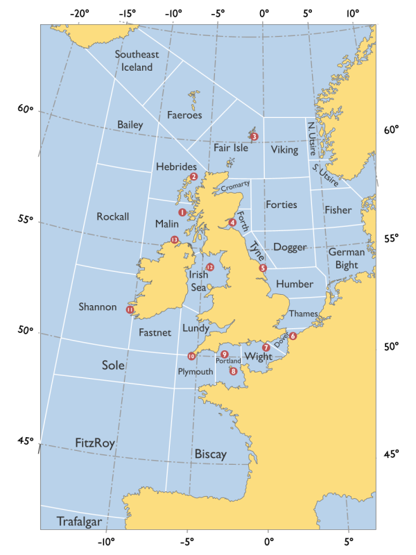
The areas are named and referred to in the forecast with a synopsis of conditions and likely conditions. These are the areas -
The forecast is given using a maximum of 370 words and always follows the same format -
Any gale warnings are first given, this is followed by the pressure in millibars then there is a forecast for each area.
The wind direction and strength using the Beaufort scale for the area(s) concerned followed by rainfall, if any, then sea state and finally, visibility.
E.g. Humber, Thames, Southeast veering southwest 4 or 5, occasionally 6 later. Thundery showers. Moderate or good, occasionally poor.
It has been a valuable tool for decades and I remember trying to decipher it for many years until I came across an explanation. My nostalgic memory is of my first real job aged 16 and having to be at work very early. This meant that I'd sit in our kitchen between 5.15am and 5.30am every morning having toast and jam.
In those days there wasn't generally 24 hour radio or even local stations. Most of the BBC would have shut down for the night and the only thing to keep me company in those first hours of the day was the shipping forecast.
The Shipping Forecast.
It is an institution of radio that has been broadcast since time immemorial and yet few people either use it properly or understand it.
Being a maritime nation the BBC, as well as normal weather forecasts, issue four times a day a special report detailing weather conditions around the coasts and further afield as an aid to fishing and shipping.
The areas are named and referred to in the forecast with a synopsis of conditions and likely conditions. These are the areas -
The forecast is given using a maximum of 370 words and always follows the same format -
Any gale warnings are first given, this is followed by the pressure in millibars then there is a forecast for each area.
The wind direction and strength using the Beaufort scale for the area(s) concerned followed by rainfall, if any, then sea state and finally, visibility.
E.g. Humber, Thames, Southeast veering southwest 4 or 5, occasionally 6 later. Thundery showers. Moderate or good, occasionally poor.
It has been a valuable tool for decades and I remember trying to decipher it for many years until I came across an explanation. My nostalgic memory is of my first real job aged 16 and having to be at work very early. This meant that I'd sit in our kitchen between 5.15am and 5.30am every morning having toast and jam.
In those days there wasn't generally 24 hour radio or even local stations. Most of the BBC would have shut down for the night and the only thing to keep me company in those first hours of the day was the shipping forecast.

