|
|
Post by mossie on Apr 14, 2013 18:46:16 GMT
Practically all my life I have been fascinated by clouds. One can imagine all sorts of animals or trees or faces, in their shapes. But the shapes change and move, all very mysterious to a child with imagination running wild. The last of the 4 jobs I had in the 2 years between school and the RAF, was as a Meteorological Assistant. At the training school we were taught to recognise the different types of cloud so that we could report them when we made our hourly observations of the weather at whatever station we happened to be posted to. Here is the broad classification of types which had been decided on internationally over 100 years ago. they are divided into three levels :-- 1. Low cloud up to about 10,000ft comprising Cumulus Stratocumulus Stratus 2. Medium cloud 10,000 to 20,000ft Altocumulus Altostratus 3. High cloud above about 20,000ft Cirrus Cirrocumulus Cirrostratus there are two other types which can be so thick as to span more than one level Nimbostratus, which is the dense solid mass of cloud, generally producing rain and often associated with a warm front, and Cumulonimbus, the thundercloud. Enough babble, here is an example of altocumulus I snapped this morning 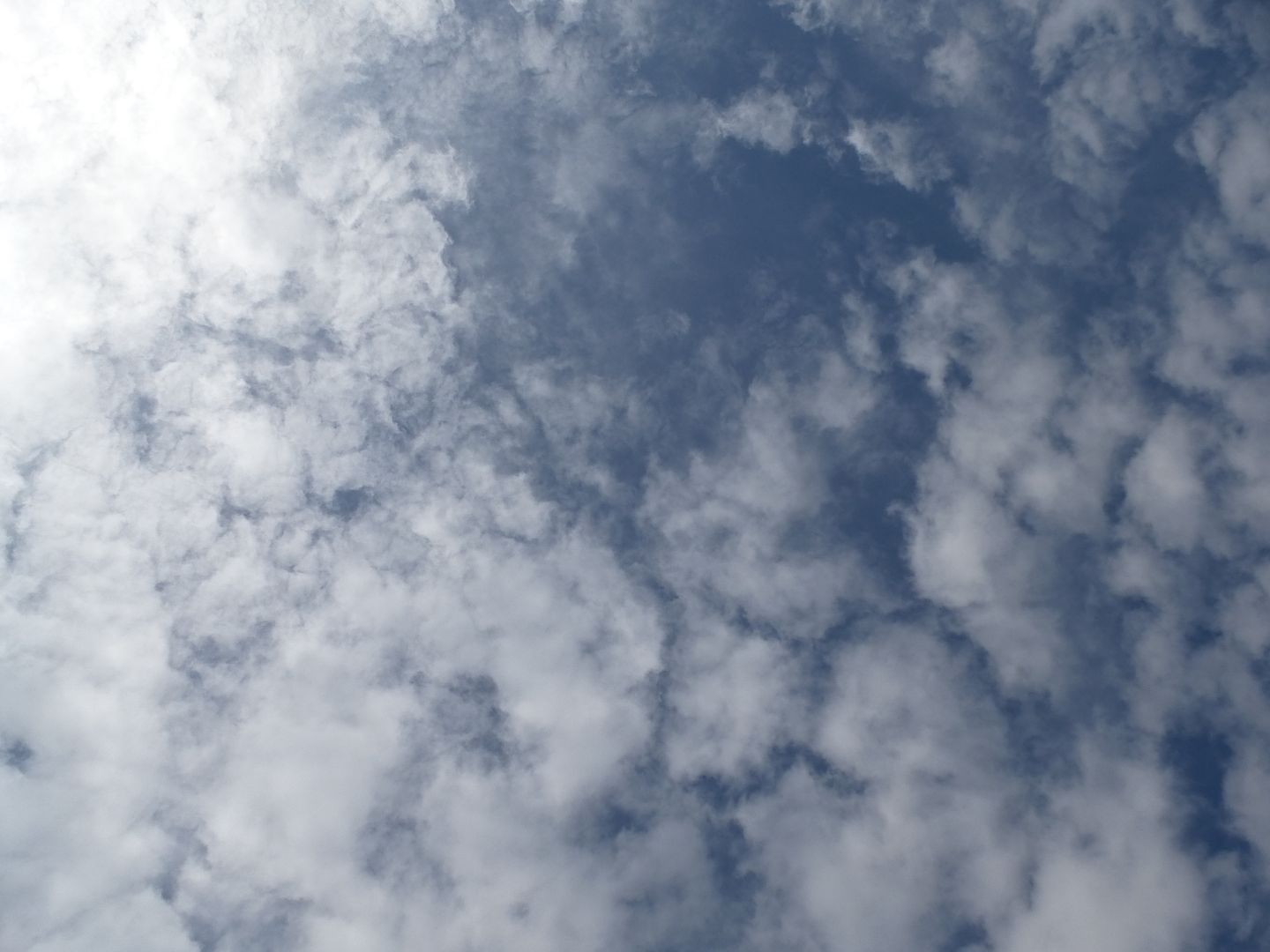 I will add some more pictures when a suitable cloud appears in front of my camera, they have not been cooperating recently. |
|
|
|
Post by mich64 on Apr 14, 2013 19:04:06 GMT
Thank you Mossie! I remembered probably 85% of the names and descriptions and enjoyed your lesson in the different classifications and types.
I look forward to more pictures identifying each! I find it a fascinating topic and remember very well how I enjoyed learning about this when in school.
|
|
|
|
Post by htmb on Apr 14, 2013 19:18:09 GMT
Very nice start, Mossie. I will look forward to watching this thread develop. I remember studying clouds in school, but that part of earth/space science was definitely not my strength.
|
|
|
|
Post by bixaorellana on Apr 15, 2013 2:45:40 GMT
Yay, Mossie! I am a tabula rasa when it comes to clouds, but really want to learn.
Okay -- altocumulus = alto, high + cumulus collected? clumped? = high, thickish clouds?
Can we post pictures of clouds for identification and learnéd discourse?
|
|
|
|
Post by Deleted on Apr 15, 2013 10:11:59 GMT
This should be a good thread. I learned all of the names of the clouds in school but the information seems to have been misplaced over the years.
|
|
|
|
Post by mossie on Apr 15, 2013 15:27:32 GMT
Sorry Bixa, I intended to give some brief description, but was afraid I had rambled on for too long.
Altocumulus is a medium level cloud which forms in clumps. Sometimes they form in regular rows and sizes and then give the familiar "mackerel sky", referring to the scales on the fish. The pedants have Latin suffixes for different types and that would be "altocumulus undulatus". the more diffuse type as in my shot would be, "altocumulus floccus". Latin floccus = a tuft of wool, from which our word flock is derived.
A very distinctive type formed over hills or mountains is "altocumulus lenticularis" because of it is shaped like a lens and generally has sharp well defined edges. It is formed when the air is forced up in the wind flowing over the hills so is termed an orographic cloud.
All cloud is formed from water condensing out of rising air, sorry you will have to refer to basic physics to believe that. Sometimes the visible drops are water, but at higher altitudes they are ice crystals.
|
|
|
|
Post by bixaorellana on Apr 15, 2013 15:46:52 GMT
Coincidentally, the day before you started this thread I began reading a novel in which the protagonist is a meteorologist. The nature descriptions are lyrical, with the added bonus of the hero interjecting the names of clouds as he admires nature.
Your expansion on the names isn't pedantic, in fact makes it easier for me to understand & to envision what kinds of clouds you're describing.
|
|
|
|
Post by mossie on Apr 15, 2013 18:45:22 GMT
You must be careful how you deal with meteorologists. A meteorologist is a man who can look deeply into a girls eyes and tell whether.  |
|
|
|
Post by bixaorellana on Apr 15, 2013 19:00:38 GMT
*coyly lowers lashes*
|
|
|
|
Post by mossie on Apr 15, 2013 21:24:11 GMT
|
|
|
|
Post by bixaorellana on Apr 15, 2013 23:18:22 GMT
Should we meet in the middle? ;D
|
|
|
|
Post by htmb on Apr 16, 2013 3:27:25 GMT
A little Joni Mitchell "Clouds" music to set the mood?
|
|
|
|
Post by mossie on Apr 16, 2013 13:36:52 GMT
Thanks htmb for dragging this thread kicking and screaming back to the subject. Here is some cumulus in its denser stages, having been clumping together for a while, and almost becoming stratocumulus. BUT it allows me to sneak in a shot taken from my favourite vantage point in Paris. Above the parc de Belleville.  Bixa..same place, same time next week ? Bixa..same place, same time next week ? |
|
|
|
Post by mossie on Apr 16, 2013 13:59:17 GMT
I'll cheat a little and throw in a snap I posted here some time ago. This includes a different type of cloud, the man made "contrail". Short for condensation trail, formed by the water condensing out of aircraft exhausts. Virtually any form of combustion produces water vapour as a by product. The other cloud type is cirrus which occurs at high altitude, typically between 25 - 35,000ft, dependent on temperature, and is composed wholly of ice crystals. This one is basically cirrostratus which gives a fine wispy veil. 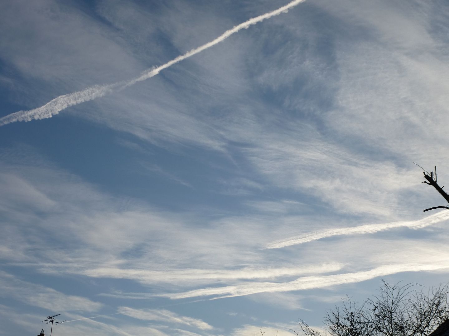 |
|
|
|
Post by htmb on Apr 16, 2013 19:58:46 GMT
The clouds in the parc de Belleville photo are very interesting and good descriptive examples, Mossie, but I really like the view from the parc, too. Nice picture!
|
|
|
|
Post by lugg on Apr 20, 2013 13:36:54 GMT
I think there are 3 different cloud types in this pic .... not sure though or what they are , over to you Mossie .  |
|
|
|
Post by mossie on Apr 20, 2013 19:24:54 GMT
Lucky you Lugg, flying over romantic atolls, South Pacific here we come. "Nothing but a Dame" I can almost hear the song.  ;D The thin cloud at the top is cirrus possibly strengthening into a bit of cirrostratus. Your airliner is getting up towards that altitude. Below is some good strong fair weather cumulus, the little wispy puffs to the right at the bottom are most likely cumulus just at the point of forming |
|
|
|
Post by lugg on Apr 21, 2013 7:31:42 GMT
Thank you Mossie, I have lots more photos of clouds to post in due course as long as it is not a chore for you.
Loved the serenade too , unfortunately I was not going as far as the South Pacific , that is my dream though one day....
|
|
|
|
Post by nautiker on Apr 21, 2013 9:33:25 GMT
I like this thread - I always keep forgetting how those different clouds are called, maybe the examples here will finally help me getting more practice :-)
|
|
|
|
Post by mossie on Apr 21, 2013 15:26:50 GMT
Here is an old one, Hooked Cirrus. In fact little clouds very high up which are raining ice  . Cirrus is composed of ice crystals and from these clouds they fall like rain, but soon evaporate as they fall into slightly higher temperature air. The upturned hook bit is the cloud and the streaks are the ice rain. The streak effect is caused by the wind, the hook is being carried by the wind, leaving the rest behind. It is often a sign of strong wind at high altitude. 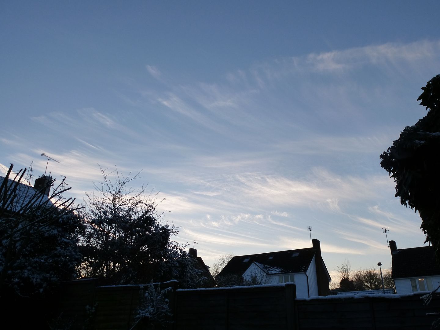 |
|
|
|
Post by bixaorellana on Apr 21, 2013 16:38:06 GMT
Beautiful picture, Lugg!
Mossie, your explanations really make the names easier to remember. Showing cirrus, then hooked cirrus will make it stick for me.
I'm assuming that knowing that the hooks are probably caused by strong winds at high altitude is part of using clouds to predict the weather. ~?~
|
|
|
|
Post by htmb on Apr 21, 2013 18:08:35 GMT
Amazing! I never knew that about the ice crystals.
|
|
|
|
Post by mossie on Apr 24, 2013 18:34:14 GMT
Here is some more cirrus and cirrocumulus, starting to mass up into cirrostratus, note the track carved into it by a careless airliner.  Later in the day it had massed further into altostratus. Although there is a suggestion of altocumulus 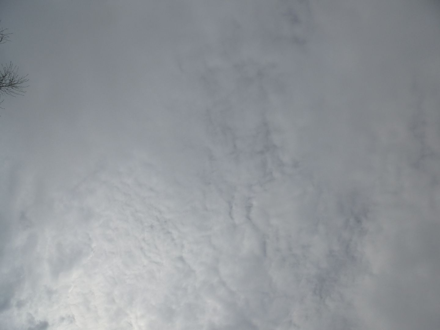 I reckon that was the remains of the warm front which gave us temperatures of 72 today (22 in funny money). We have jumped from winter to summer in about 10 days. |
|
|
|
Post by lugg on Apr 24, 2013 20:03:59 GMT
22C wow - it only got to about 17 here in the Marches.
Wonderful photos and explanations Mossie
|
|
|
|
Post by bixaorellana on Apr 25, 2013 13:16:51 GMT
That's fascinating about the cirrus clouds being ice. Great pics, Mossie.
|
|
|
|
Post by mossie on Apr 25, 2013 19:45:48 GMT
I can see I shall have to go back to the physics text books to make sure of my facts. However cirrus type clouds form in the area above about 20,000 ft, with the upper limit normally being the tropopause, this is the boundary between the troposhere and the stratosphere. This varies between about 30,000 ft at the poles to 50,000 ft at the equator. The temperature here is of the order of -50 C, but in order to give you a comfortable flight and to save fuel, airliners routinely fly in the stratosphere, so Mitt opening a window is not a very bright idea ;D. The outside pressure is about one third of ground level which is the reason for cabin pressurization. If you venture out at that level expect your stomach to swell over twice its size, the wind is nothing  , and you would fairly quickly lose consciousness without oxygen. Having experienced explosive decompression at 38,000 ft I can assure you that is not an experience I wish to repeat ;D ;D ;D Here endeth the first lesson. |
|
|
|
Post by Deleted on Apr 25, 2013 19:51:34 GMT
Explosive decompression at 38,000 ft?? And you lived to tell the tale?!?!?
|
|
|
|
Post by htmb on Apr 25, 2013 22:00:28 GMT
I have no idea how high we were, but I was on a charter flight that lost air pressure. Something to do with a valve. The cabin got extremely cold and the oxygen masks dropped down. The pilot rapidly descended to a lower altitude without making any sort of announcement..... We had just been in stormy weather, but I have no idea if that was a factor.
|
|
|
|
Post by mossie on Apr 29, 2013 7:25:35 GMT
Airliners are pressurised by air bled off from an engine being fed into the fuselage. This is to maintain a pressure to keep pax comfortable. To regulate the pressure a"blow off" valve opens to allow excess air out, this most likely got stuck open. My incident occurred when the nice big bubble hood unlocked and slid back on its rail, so our pressure was unloaded instantly. As were our ears and lungs, not to mention inflation of the stomach, the wind blew ;D. We made 38,000 to 1,500 in under 3 minutes, I couldn't wait to hit the mess bar |
|
|
|
Post by mossie on Apr 29, 2013 7:28:24 GMT
Having problems with my main computer at present, this is via my iPad, normal service will be resumed shortly. I hope ;D
|
|


 . Cirrus is composed of ice crystals and from these clouds they fall like rain, but soon evaporate as they fall into slightly higher temperature air. The upturned hook bit is the cloud and the streaks are the ice rain. The streak effect is caused by the wind, the hook is being carried by the wind, leaving the rest behind. It is often a sign of strong wind at high altitude.

