|
|
Post by htmb on Aug 29, 2016 20:42:40 GMT
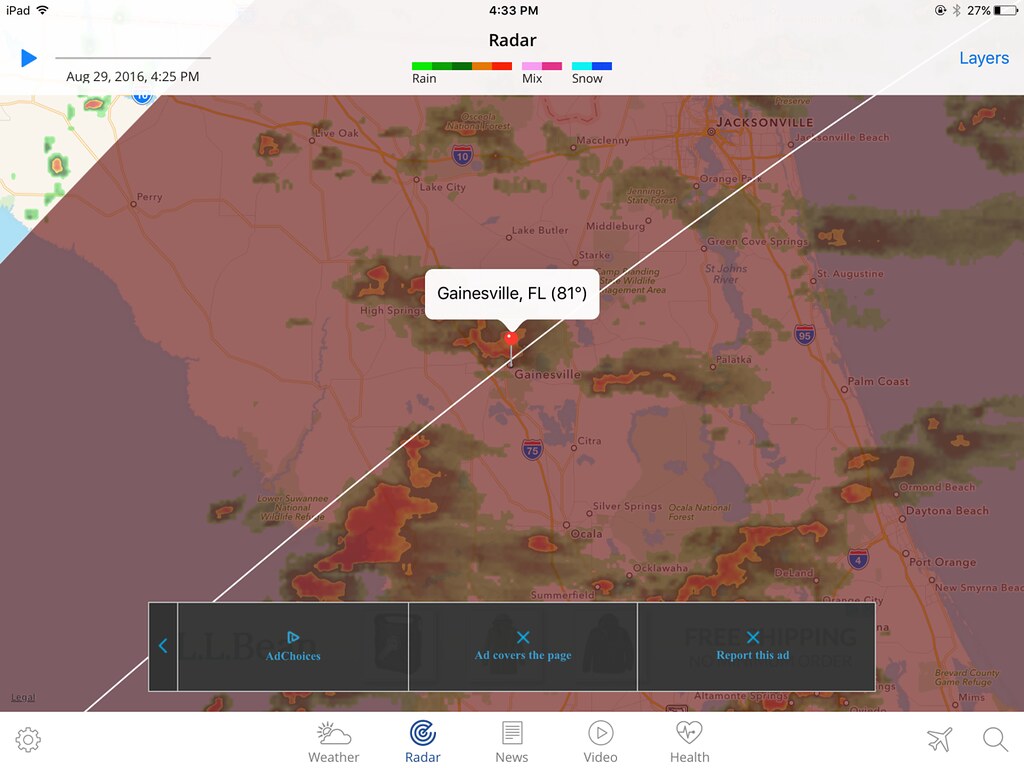
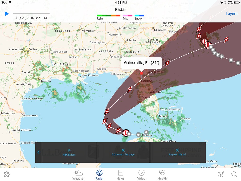
The Weather Channel makes it look even more ominous. This is what I get when I look at the radar for my area.  And, zooming out.  We'll just have to keep an eye on the weather. These things can always change and wander where they will. It sounds like Cuba is getting pounded pretty hard with heavy rain. There have been thunderstorms off and on here today, but I have no idea if they are related to the storm system to the south. |
|
|
|
Post by htmb on Aug 30, 2016 22:16:14 GMT
The prediction above still hasn't changed, but anything can happen over the next 24 hours. Currently the storm is projected to make landfall on the west coast of Florida at Cedar Key on Thursday afternoon before crossing the state. Winds may reach hurricane force along the west coast, and it will probably be high tide at the time of predicted impact. Cedar Key and other coastal areas could be in for some problems. Inland, we're looking at a lot of rain, but could also experience high winds and the chance of tornados. The storm is still a tropical depression, but is forecasted to strengthen overnight as it begins to turn to the northeast.
|
|
|
|
Post by bjd on Aug 31, 2016 5:35:13 GMT
I hope your roof has been fixed, htmb.
|
|
|
|
Post by htmb on Aug 31, 2016 13:03:52 GMT
I hope your roof has been fixed, htmb. The workers haven't finished, since that part of the roof is also a deck needing lots of repair. However, it poured during the night and, since nothing leaked, I'm hopeful they've taken care of the problem. |
|
|
|
Post by Deleted on Aug 31, 2016 13:40:01 GMT
Strange how "9" just keeps sitting there not doing anything.
|
|
|
|
Post by htmb on Aug 31, 2016 18:16:40 GMT
The storm has now been named Tropical Storm "Hermine," after becoming more cohesive with strengthening winds. While we should catch a good bit of it, the path is forecast to go a bit to the north. Our local schools have not been canceled for Thursday when the storm is supposed to come inland, so I'm guessing the district officials were told to expect a lot of heavy rain with some wind gusts, but not much else.
|
|
|
|
Post by Deleted on Aug 31, 2016 19:09:40 GMT
Meanwhile they're saying here that Gaston is extremely powerful and could cause some major weather problems when it reaches Europe -- not as a hurricane of course.
|
|
|
|
Post by htmb on Sept 1, 2016 15:03:24 GMT
The storm is predicted to hit the coast with hurricane force winds later today as it finally begins to move. The projected path has been adjusted farther to the north, but it looks like we have a lot of rain headed our way. |
|
|
|
Post by Deleted on Sept 1, 2016 15:41:23 GMT
My main objective in seeking out a computer this a.m. was to check in and offer a wish for safe keeping to you and yours HTMB.
I hope you are spared any destruction etc.
|
|
|
|
Post by htmb on Sept 1, 2016 16:22:22 GMT
Thanks very much, Casimira.  |
|
|
|
Post by htmb on Sept 1, 2016 19:37:49 GMT
We now have 75 MPH "Hurricane Hermine"
Our schools have been cancelled for tomorrow. Officials in counties directly south of us have reported tornadoes. We are currently under a tornado watch, meaning conditions are favorable for their development.
The nasty weather has started affecting the state of Florida.
|
|
|
|
Post by Deleted on Sept 1, 2016 19:59:40 GMT
I saw that the Tampa area had already cancelled school today due to huge rains and flooding caused by Hermine.
Has your rain begun yet, htmb?
|
|
|
|
Post by htmb on Sept 1, 2016 20:09:41 GMT
We have had clouds and lots of rain off and on for days as the storm strengthened.
In the last fifteen minutes the sky has gotten even darker and we are currently experiencing heavy rain, lightening and thunder. Not much wind yet, but it's on the way.
|
|
|
|
Post by htmb on Sept 1, 2016 22:16:34 GMT
It's interesting to now see circular bands all the way around a center, indicating a fully developed hurricane. |
|
|
|
Post by Kimby on Sept 1, 2016 22:44:51 GMT
I'm hearing from neighbors on Sanibel Island that the beach is being lashed by large waves, inundating many of the sea turtle nests and jeopardizing survival of the next crop of turtle offspring.
Being located to the South of a Gulf coast hurricane's landfall puts one directly in the path of the largest storm surge, due to the counter-clockwise rotation. (On the Atlantic coast, it's just the opposite - you want to be to the south there.)
|
|
|
|
Post by htmb on Sept 2, 2016 6:14:08 GMT
Lots and of wind and rain here. My electricity has been out for about 45 minutes.
|
|
|
|
Post by mossie on Sept 2, 2016 7:01:38 GMT
Pleased to hear from you htmb, was wondering how things were in Gainesville.
|
|
|
|
Post by htmb on Sept 2, 2016 12:01:23 GMT
Still no power, so I'm not sure about the rest of North Florida, but things are okay at my home.
|
|
|
|
Post by fumobici on Sept 2, 2016 14:08:15 GMT
I think it's amazing we can still access the internet, even when our power is out (at least until our phone batteries run out). Hope you don't see any real damage and get your lights back on soon.
|
|
|
|
Post by htmb on Sept 2, 2016 15:12:44 GMT
Thanks, Fumobici. I have power again, for now anyway. There's another strong band of storms currently moving through the area, so we're not totally finished with the bad weather.
Being able to use a phone when the power is out is one reason I also keep my landline.
At least I've had water the whole time. My children and grandchildren were visiting their father who lives in a rural area. Since he has a pump and well, they were unable to use the water once they lost power.
|
|
|
|
Post by Deleted on Sept 2, 2016 17:13:48 GMT
From what I saw on BBC News, it looks like Cedar Key got hit exceptionally hard.
|
|
|
|
Post by htmb on Sept 2, 2016 19:23:53 GMT
Yes, it sounds like there was a lot of damage there. While I can get on Anyport, I'm still having a hard time getting much of a cell signal and our cable is out. No internet or tv. I had heard the remote camera at cedar key had been knocked out by wood from one of the docks. I saw some of the feed earlier last night and there was a lot of water across dock street. I know some of the business owners along the shore had planned to ride out the storm to try and protect their property. I hope they are all safe.
|
|
|
|
Post by Deleted on Sept 2, 2016 21:02:59 GMT
Glad to hear you are safe HTMB.
(I keep a landline as well for the very same reason).
I have family all along the Atlantic coast from the Carolinas on up to Long Island.
I hope they are spared too much devastation.
|
|
|
|
Post by mich64 on Sept 2, 2016 23:25:53 GMT
Happy to read that the repair so far on your roof were enough to keep the water out htmb!
Hopefully damage is minimal at Cedar Key an the other places the hurricane past over.
We kept our land line until last year. I had been holding on to it because of my fear of power outages but with having the generator we are able to keep our mobiles charged along with the fridge, some plug outlets, the television, satellite and some lights. We have had to use it a few times this summer when we lost power during storms.
|
|
|
|
Post by Deleted on Sept 4, 2016 4:19:05 GMT
I was following the advisories of the National Hurricane Center, and it looks like they got in a fight there. Once Hermine popped out into the Atlantic and began to strengthen again there was an advisory yeaterday morning saying "This is the last advisory due to the fact Hermine is no longer a tropical storm but has become a post-tropical storm. For further information on the situation, please consult the Météo France high seas report (!!) at the following link..." That message disappeared, and the advisories have continued now. I can imagine that somebody must have hit the ceiling about the idea of abandoning advisories when the storm was just a few kilometres off the coast of the Carolinas, particularly in view of what happened with 'post-tropical storm Sandy' a few years ago. I suppose that one of the flunkies was just following the instructions in the 'advisory rule book' without asking superiors, probably in the middle of the night local time.
But the main thing that I found surprising was the idea that an official American agency would say to consult Météo France for information about weather still happening in the United States territorial zone.
|
|
|
|
Post by htmb on Sept 4, 2016 4:22:03 GMT
Interesting. We were just reading about a state of emergency in New Jersey.
|
|
|
|
Post by htmb on Oct 1, 2016 15:05:53 GMT
Hurricane Matthew popped up recently off the coast of Venezuela and quickly escalated to a category 5 powerhouse. It is still moving to the west, but is expected to turn and impact the island of Jamaica and cross the eastern part of Cuba. If it travels the projected path it will cross over the Bahamas and may also affect the east coast of Florida. All will depend upon when it begins the anticipated turn to the north.
|
|
|
|
Post by Deleted on Oct 1, 2016 18:18:08 GMT
I have been keeping a keen eye on Matthew as well HTMB and hope you and yours and mine stay out of harms way and that this storm does not interfere with your travel plans to the NE.
We aren't due to travel up there until the 12th but, havoc of this sort could most certainly put a major "damper" on my brother's wedding which is smack dab on the water....
Not to trivialize the horrid conditions that could possibly occur involving more serious consequences for many on the coastline.
|
|
|
|
Post by htmb on Oct 1, 2016 21:55:39 GMT
Thanks, Casimira. We'll hope for the best for everyone, though the islands don't look like they are in the best of positions.
There's been some change as the last report showed Matthew turning towards the NW.
|
|
|
|
Post by bixaorellana on Oct 4, 2016 4:12:04 GMT
|
|